In today’s world of cell phones and a computer in almost all homes, it is easy to use these items to implement high tech training aids into our flying. To do this all we really need is a cell phone and internet service however, we will take a look at a few other free tools that can improve the data we get.
What you will need for this project;
- Smart phone
- Computer
- Free software
What we are looking for…
GPS SVG data
GPS elevation profile flight tracking
Google Earth
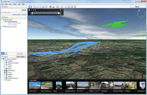
Google Earth 3D
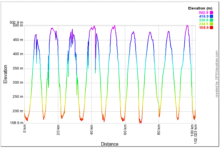
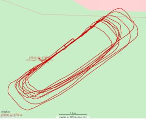
It is important to point out that the data we receive from this method is only so reliable. There will be errors and deviations in the data but overall, especially top down, we can gather some very useful information. The data I will use during this demonstration is data gathered during practice pattern maneuvers. You will be able to see some of the deviations that took place. Some of them are due to setting set to gather data at a slower rate then available and some due to inaccuracies in the GPS link.
The App
The first thing we need to do is download and install a GPS data tracker into the phone. All cell phones made today have GPS built into them. These apps take the data from the GPS and store them into a file which can be downloaded and manipulated into visual data. This data is stored in a .gpx file and the file is divided into sections for each point.
The logger that I used for this example is called “GPS Logger (free version)” on an Android platform. The app itself is not all that important as long as it records the correct data. There are many apps that will work for this including Android, iOs and Windows platforms.
The Data
The data is stored in a file that is essentially a .xml file but the extension is .gpx. This is really nothing more than a text document with some “tags” that tell the software when to stop and start with specific data.
The .gpx file that the logger creates looks like this (one point of data);
<trkpt lat=”36.04897329″ lon=”-79.47920946″><ele>206.860<speed>0.000<time>2016-11-02T21:55:12Z</trkpt>
It’s not important that you understand the file, in fact all you really need to do is be able to locate the file on your phone to upload to the web site. So if your not a “coder”, skip down to “Plotting your data”.
trkpt – Indicates a new tracking point. This is simply a point in the track where the GPS “grabbed one set of data.
lat – This is the latitude point of the data.
lon – The longitude point of the data.
ele – Elevation
speed – Speed
time – Date and time
/trkpt – Signifies the end of that data set
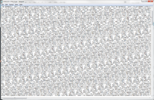
Your file will likely have many lines that look like this. Each time the logger plots a point it adds one of these lines. If desired, you can open the file using a code editor and view, edit or remove portions of the data if desired. One reason to do this is if you have an obvious rouge point, you can remove the point to help align the data and get a better plot. If you were to open this file in notepad or other simple text editor, it is not easy to read or manipulate. An easy way to overcome this is to use Notepad++. This is a very small simple program very much like Notepad however, it will format the data using line breaks and color coding to help read the data.
Data Using Notepad
Data Using Notepad++
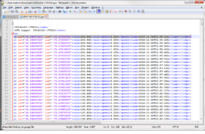
As you can see, Notepad++ make a very big difference in reading data. When editing, you can simply type in, delete, etc. as long as you do not disrupt the trkpt tags.
Example:
Original
<trkpt lat=”36.04897329″ lon=”-79.47920946″><ele>206.860<speed>0.000<time>2016-11-02T21:55:12Z</trkpt>
Good Edit
<trkpt lat=”36.00000000” lon=”-79.44444444“><ele>206.000<speed>99.999<time>2016-11-02T21:55:12Z</trkpt>
Bad Edit
<trkpt lat=”36.04897329″ lon=”-79.47920946″><ele>206.860<speed>0.000<time>2016-11-02T21:55:12Z</trkpt>
Pingback: GPS Tracking Flight Paths Without Expensive Equipment – Part 2 |